File:11-09-fotofluege-cux-allg-25a.jpg

Original file (2,848 × 2,848 pixels, file size: 5.53 MB, MIME type: image/jpeg)
This file is from Wikimedia Commons and may be used by other projects. The description on its file description page there is shown below.
Summary
| Description11-09-fotofluege-cux-allg-25a.jpg |
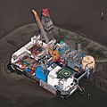
Deutsch: Fotoflug Nordsee; Ölbohrinsel im Ölfeld Mittelplate
English: Germany’s largest oil field Mittelplate
Español: Vista aérea de la plataforma petrolera de Mittelplate, el mayor yacimiento petrolífero de Alemania.
Français : Vue aérienne de Mittelplate, le plus grand champ pétrolifère d'Allemagne
Polski: Platforma wiertnicza na największym niemieckim polu naftowym „Mittelplate” znajdującym się na Morzu Północnym.
Português: Vista aérea da plataforma petrolífera de Mittelplate, o maior campo de petróleo da Alemanha. |
|||||||||||||||||||||||
| Date | ||||||||||||||||||||||||
| Source | Own work | |||||||||||||||||||||||
| Author |
creator QS:P170,Q15080600
|
|||||||||||||||||||||||
| Permission (Reusing this file) |
creator QS:P170,Q15080600 |
|||||||||||||||||||||||
| Other versions |
 |
|||||||||||||||||||||||
| Camera location | 54° 01′ 19.61″ N, 8° 44′ 08.41″ E | View this and other nearby images on: OpenStreetMap |
|---|
Assessment
|

|
This image was selected as picture of the day on Wikimedia Commons for 2 February 2016. It was captioned as follows: English: Germany’s largest oil field Mittelplate Other languages:
Bosanski: Najveće naftno polje u Njemačkoj, Mittelplate Català: Mittelplate, el camp petrolier més gran d'Alemanya. Deutsch: Fotoflug Nordsee; Ölbohrinsel im Ölfeld Mittelplate English: Germany’s largest oil field Mittelplate Español: Vista aérea de la plataforma petrolera de Mittelplate, el mayor yacimiento petrolífero de Alemania. Italiano: Vista aerea della piattaforma petrolifera di Mittelplate, il principale giacimento petrolifero tedesco. Português: Vista aérea da plataforma petrolífera de Mittelplate, o maior campo de petróleo da Alemanha. Suomi: Mittelplate, suurin öljykentän Saksan. Македонски: Мителплате — најголемото нафтено поле во Германија. Русский: Миттельплате, крупнейшее месторождение нефти Германии. 한국어: 독일에서 가장 큰 유전 미텔플라테. 中文: 德国最大油井 Mittelplate 中文(繁體): 德國最大油井 Mittelplate |

|
This image was selected as picture of the day on Vietnamese Wikipedia.
|
Licensing

|
Dieses Foto entstand aufgrund eines Projektes, das von Wikimedia Deutschland e. V. gefördert wurde.
Im Rahmen des „Community-Projektbudgets“ sollen Luftbilder u.a. von Inseln, Halligen, Sanden und Küstenorten der deutschen Nordseeküste angefertigt werden. Das Projekt „Fotoflüge“ wurde im September 2011 begonnen. |
- You are free:
- to share – to copy, distribute and transmit the work
- to remix – to adapt the work
- Under the following conditions:
- attribution – You must give appropriate credit, provide a link to the license, and indicate if changes were made. You may do so in any reasonable manner, but not in any way that suggests the licensor endorses you or your use.
- share alike – If you remix, transform, or build upon the material, you must distribute your contributions under the same or compatible license as the original.

Captions
Items portrayed in this file
depicts
4 September 2011
54°1'19.607"N, 8°44'8.408"E
image/jpeg
70d474aff9a014334be8b0051e253b6ce097ccb1
5,793,952 byte
2,848 pixel
2,848 pixel
0.002 second
11
200
82 millimetre
File history
Click on a date/time to view the file as it appeared at that time.
| Date/Time | Thumbnail | Dimensions | User | Comment | |
|---|---|---|---|---|---|
| current | 20:40, 13 January 2015 |  | 2,848 × 2,848 (5.53 MB) | wikimediacommons>Ralf Roletschek | volle Auflösung aus Original |
File usage
The following 2 pages use this file:
Metadata
This file contains additional information, probably added from the digital camera or scanner used to create or digitize it.
If the file has been modified from its original state, some details may not fully reflect the modified file.
| Camera manufacturer | NIKON CORPORATION |
|---|---|
| Camera model | NIKON D300S |
| Author | Ralf Roletschek |
| Copyright holder |
|
| Exposure time | 1/500 sec (0.002) |
| F Number | f/11 |
| ISO speed rating | 200 |
| Date and time of data generation | 11:12, 4 September 2011 |
| Lens focal length | 82 mm |
| User comments | Foto by Marcela |
| Altitude | 490.348 meters above sea level |
| City shown | Friedrichskoog-Spitze |
| Width | 2,848 px |
| Height | 2,848 px |
| Bits per component |
|
| Pixel composition | RGB |
| Orientation | Normal |
| Number of components | 3 |
| Horizontal resolution | 240 dpi |
| Vertical resolution | 240 dpi |
| Software used | Adobe Photoshop CC 2014 (Windows) |
| File change date and time | 21:38, 13 January 2015 |
| Exposure Program | Normal program |
| Exif version | 2.21 |
| Date and time of digitizing | 11:12, 4 September 2011 |
| APEX shutter speed | 8.965784 |
| APEX aperture | 6.918863 |
| APEX exposure bias | 0 |
| Maximum land aperture | 4.4 APEX (f/4.59) |
| Metering mode | Pattern |
| Light source | Unknown |
| Flash | Flash did not fire |
| DateTime subseconds | 16 |
| DateTimeOriginal subseconds | 16 |
| DateTimeDigitized subseconds | 16 |
| Color space | sRGB |
| Sensing method | One-chip color area sensor |
| File source | Digital still camera |
| Scene type | A directly photographed image |
| Custom image processing | Normal process |
| Exposure mode | Auto exposure |
| White balance | Auto white balance |
| Digital zoom ratio | 1 |
| Focal length in 35 mm film | 123 mm |
| Scene capture type | Standard |
| Scene control | None |
| Contrast | Normal |
| Saturation | Normal |
| Sharpness | Normal |
| Subject distance range | Unknown |
| GPS time (atomic clock) | 09:12 |
| Geodetic survey data used | WGS-84 |
| GPS date | 2011-09-04 |
| Serial number of camera | 6090043 |
| Lens used | 50.0-200.0 mm f/4.0-5.6 |
| Rating (out of 5) | 0 |
| Date metadata was last modified | 22:38, 13 January 2015 |
| Unique ID of original document | xmp.did:52A5AB643AD7E01196069FB2834CFB77 |
| Keywords | Friedrichskoog-Spitze, Schleswig-Holstein, Deutschland |
| Country shown | Deutschland |
| Province or state shown | Schleswig-Holstein |

