File:DurbanSign1989.jpg
From KYNNpedia

Size of this preview: 352 × 600 pixels. Other resolutions: 141 × 240 pixels | 587 × 1,000 pixels.
Original file (587 × 1,000 pixels, file size: 361 KB, MIME type: image/jpeg)
This file is from Wikimedia Commons and may be used by other projects. The description on its file description page there is shown below.
|
Summary
| DescriptionDurbanSign1989.jpg |
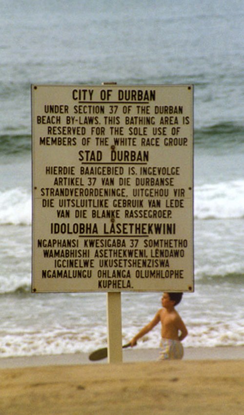
Afrikaans: Teken in Durban wat sê die strand is net vir witmense kragtens artikel 37 van die Durbanese strandverordeninge. Die tale is Engels, Afrikaans en Zoeloe, die taal van die swart bevolkingsgroep in die Durban gebied.
Deutsch: Schild in Durban, welches besagt, dass der Strand gemäß Artikel 37 der Strandverordnung Durbans nur für Weiße zugänglich ist. Die Sprachen sind Englisch, Afrikaans und Zulu, die Sprache der schwarzen Bevölkerung im Großraum Durban.
English: Sign in Durban that states the beach is for whites only under section 37 of the Durban beach by-laws. The languages are English, Afrikaans and Zulu, the language of the black population group in the Durban area.
Français : Pancarte à Durban expliquant que la plage est uniquement réservée aux blancs conformément à l'article 37 de l'arrêté de Durban sur la plage. Les langues exposées sont l'anglais, l'afrikaans et le zoulou, la langue de la population noire habitant en zone de Durban.
Español: Letrero de aviso en Durban que indica que la playa es solo para blancos según la sección 37 de los estatutos de la playa de Durban. Los idiomas son inglés, afrikaans y zulú, el idioma del grupo de población negra en el área de Durban.
IsiZulu: Isaziso saseThekwini esithi ibhishi labelungu kuphela ngokwesigaba 37 semithetho kamasipala yaseThekwini. Izilimi ezisebenzisiwe isiNgisi, isiBhunu kanye nesiZulu, ulimi lwabantu abamnyama basendaweni yaseThekwini. |
||||||||
| Date | |||||||||
| Source |
Afrikaans: Dié foto is geneem en beskikbaargestel deur Guinnog.
Deutsch: Geschossen und bereitgestellt von Guinnog.
English: Taken and donated by Guinnog.
Français : Prise et donnée par Guinnog.
Español: Tomado y donado por Guinnog.
IsiZulu: Isithombe esithathwe futhi sanikelwa nguGuinnog. |
||||||||
| Author | Guinnog | ||||||||
| Permission (Reusing this file) |
|
||||||||
| Other versions |
|
| Camera location | 29° 53′ 00″ S, 31° 03′ 00″ E | View this and other nearby images on: OpenStreetMap |
|---|
Captions
Racist sign. Durban, South Africa, 1989
1989
29°52'59.999"S, 31°3'0.000"E
image/jpeg
File history
Click on a date/time to view the file as it appeared at that time.
| Date/Time | Thumbnail | Dimensions | User | Comment | |
|---|---|---|---|---|---|
| current | 05:45, 15 March 2008 |  | 587 × 1,000 (361 KB) | wikimediacommons>Guinnog | larger version, slight crop |
File usage
The following page uses this file:

